Tuesday, 6 February 2018

Some Natural Areas of Chatham-Kent, Part 4 (Mitchell's Bay North)

Moving a little south of the Bear Creek Unit of St. Clair NWA described in Natural Areas of C-K, Part 3, but still staying along the shoreline of Lake St. Clair, we come to the Mitchell's Bay North Lake Shore Nature Trail. It has only been open since the fall of 2015.

My first recollection of this site is a result of giving a colleague an aerial tour of the shoreline of the district in April of 1989. As we flew by, it really stood out. It was a private marsh, and to enhance it for waterfowl nesting, a 'cookie cutter' dredge was used to increase the openness and edge of the site. Note the black soil beyond the wetland. These are very rich soils that developed from the tallgrass prairie and/or wetland vegetation, depending on the lake levels, in historic times.
Fast forward to 2017, and the aerial view, compliments of Google, has the site looking like this.
It isn't the same scale as the previous photo, but I set it like this to show the length of the trail, as marked by the blue line, and also to show it relative to Mitchell's Bay and Bass Haven. Some of the squiggly lines depicting open water that were present in 1989 are still visible today. But some additional work has been done.

Parking is limited to where the 'X' is, as well as along one side of the gravel road.

There is a well marked, fine gravel trail marked in blue, which leads along some of the canals and in the wetland part, leads to a higher spot overlooking the part of the lake called Mitchell's Bay. The sides of the berms have been restored to tallgrass prairie, which would have been dominant here at the time of settlement, depending on the lake levels.


The abundant flowers of the tallgrass prairie are wonderful for attracting butterflies and other insects.
Clouded Sulphur

Little Wood Satyr
 Without trying too hard, I've recorded at least 15 species of butterflies to date. There are possibly another dozen that could occur. One of the rarest ones I've seen here is this next one, known as a Little Yellow.

As you can see from the map above, there are several channels through the site. With a few logs strategically placed, there are great opportunities to see water birds as well as reptiles and amphibians basking.
 Bullfrogs used to be extremely abundant in the marshes along this side of Lake St. Clair, and at times in the evening, their chorus could be almost deafening. Unfortunately in the last couple of decades or so, their numbers have dropped dramatically. There are still some to be found however.
Bullfrog

This next photo was taken from the very end of the gravel trail, and it is elevated a bit to give a better view. Off in the distance to the right, is the south end of the Walpole Island First Nation.
From here, you can often see various water birds, especially when the young have hatched and they are swimming about exploring their territory.
Common Gallinule

Pied-billed Grebe

Mute Swan
 Mute Swans can be quite abundant at times, and sometimes more than 100 are visible across the bay towards Walpole, especially in the late summer and early fall. This adult with the young, known as cygnets, were raised here. Unfortunately as photogenic as this species is, it is not native to North American, and therefore an undesirable species of natural areas to say the least. They are very aggressive towards native waterfowl, driving them away and interrupting the nesting activities of native species.

This next photo was opportunistic during the late fall of 2017, when I was able to photograph these two swans: a Mute Swan on the left and a Trumpeter Swan on the right.

Given that Mute Swans are quite aggressive, you would hardly ever see them tolerate being this close to a Tundra Swan, the sometimes abundant swan that migrates through in the spring and the fall. However Trumpeter Swans are about the same size as a Mute Swan, sometimes slightly larger, and they will not be scared off by the Mute. In fact at one point this Trumpeter Swan was seen aggressively chasing the Mute! Trumpeters are native species, that according to many authorities, used to breed in this area. (There are differing opinions on this, but I believe they were historically native to this area.) They were wiped out of the east back in the 1800s and early 1900s, and up until 2-3 decades ago, were limited in North America largely to some of the larger wetlands and lakes of the far west. But a reintroduction of the Trumpeter Swan was initiated in the 1970s in the north central part of Ontario. The population has gradually expanded elsewhere in southern Ontario, and we are now seeing a handful appearing in some of the larger wetlands here in Chatham-Kent. It used to be an extreme rarity to see them here at all; now it has become an annual event. Hopefully some will become permanent residents and re-establish a breeding population.

Other birds appear feeding in the area, or just passing through. There have been ~130 species of birds recorded along this trail to date, not bad since it has only been accessible for a short time, and birders hardly ever visit. In fact of all the times I have been at this natural area, I have only seen one or two other people there. It is definitely a great place to see lots of wildlife in a quiet setting.

Great Blue Herons do not nest here, but do so a short distance away at Walpole.

Northern Harriers, a.k.a. Marsh Hawks, probably nest in some of the larger wetlands along Lake St. Clair, and may be seen hunting over the cattails.
 On some occasions, the view across the wetland can be a terrific spot to capture an attractive sunset.


Next up will be the Mitchell's Bay South Lake Shore Trail.


Saturday, 3 February 2018

Some Natural Areas of Chatham-Kent, Part 3

This post will describe two areas that are publicly owned per the federal government and administered by the Canadian Wildlife Service branch of Environment and Climate Change Canada: St. Clair National Wildlife area and the Bear Creek Unit of SCNWA.

St. Clair National Wildlife Area
Many people may have heard about this place, but it is surprising how many times I come across residents of C-K who don't know where it is, let alone having visited it. This first photo shows the location of the NWA along the east shore of Lake St. Clair relative to the surrounding landscape. There are quite a few wetland complexes along this east shore. Before settlement, the water of the lake would vary and during higher water levels, the area of wetland moved inland quite a bit. During periods of lower water levels, the wetland would be tallgrass prairie. The soils here are extremely productive from an agricultural perspective; hence much of the area has been drained and turned into farmland. Fortunately some big business corporations recognized the value of some of these wetlands for duck hunting, and acquired significant tracts of the wetlands before they were drained and converted to farmland.
 This next photo shows a closer look at the ~240 hectares (~600 acres) that are outlined in blue, which make up the NWA. This wetland is contained within a dyke system, making it less subject to the adjacent lake levels. Water levels inside the NWA are controlled by a pump system.

This was owned by executives of the Stroh Brewing Company out of Michigan until it was put on the market and the CWS acquired it in the 1970s. Even though it is publicly owned by CWS, most of it is off limits to the general public. The E in the lower right hand corner marks the road access, which goes to a small parking lot, marked at X. The red line marks the trail, starting from the parking lot, and goes along the top of a dyke.
Here are a couple of signs you will see as you enter the NWA.


The trail along the dyke is a gravel surface and in good condition. An observation tower is about a 12 minute walk from the parking area.
You will quickly notice as you travel along that this NWA is predominantly wetland.

The NWA has been identified as a Wetland of International Importance. This post is particularly timely, since yesterday, Feb 2, is proclaimed as World Wetlands Day in recognition of the International Wetland agreement that was signed on this day in 1971, in Ramsar, Iran, and has since been referred to as the Ramsar Convention. Sites that have been nominated and accepted as qualifying sites are known as Ramsar sites.

The larger, more extensive complex of wetland along the Lake St. Clair shoreline that SCNWA is part of has also been recognized as an Important Bird Area. Waterfowl was one of the main reasons big businesses acquired many of these wetlands decades ago. The area is where two waterfowl migratory flyways overlap, and the shallow water of the lake as well as the shelter of the extensive marshes have always been of great importance to migrating, as well as nesting waterfowl. Tundra Swans pass through the area in large numbers.....
....as do Canada Geese, some of which will stay most winters.
There are tens of thousands individuals of two dozen or more other species of waterfowl that migrate through, and typically 10-15000 will remain all winter.

Of course wetlands are important to more birds than just waterfowl. There are about 235 species of birds that, to date, have been identified here. Many marsh birds, including Great Egrets, use the area. Great Egrets don't nest in the NWA, but do so in the extensive wetlands of Walpole Island First Nation, at the north end of the lake. But dozens of them will use the NWA for feeding and resting. In fact when the water levels are low enough, sometimes more than 100 of them will roost overnight later in the season, as this next photo shows.
This photo, showing part of the roost, was taken about a half hour before sunrise, with a telephoto lens and a slow shutter speed. Fortunately when the birds are still in their roost, they are quite motionless, enabling the slow shutter speed to work.

The early morning hours or late evening hours are sometimes the best time to visit, as the wind is quieter and wildlife tends to be a little more active. One can also enjoy some very nice sunrise or sunset conditions.

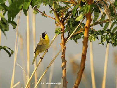
There are other birds as well, some quite common such as this Common Yellowthroat.
Some rarities migrate through, such as this Nelson's Sparrow, a small and very furtive bird that probably passes through in small numbers annually, but is seldom seen.
Then there are extreme rarities, such as one of the few records of Vermilion Flycatcher for Ontario, found late in the season one year in the early 1990s, but did not stick around for the Christmas Bird Count. Another rarity was a July appearance of a White-winged Dove in the early 2000s.

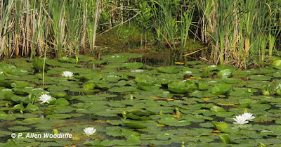
Plants are a big part of a wetland. Cattail is the most dominant emergent species, but at times the open water areas are covered with Fragrant Water Lily.


A somewhat similar looking species is this much rarer and larger American Lotus. It isn't officially rare, but could be. It is limited largely to a few wetland areas of Chatham-Kent and Essex.
A legally rare species is Swamp Rose Mallow.
It is quite colourful, and may grow up to two metres high in shallow water, and is most visible in late July through August. It can be quite abundant in some of the larger marshes of Chatham-Kent and Essex, although it does grow in much smaller numbers in other municipalities of southwestern Ontario.

There is much more that could be said about this wonderful natural area, but why not go out and explore it for yourself?

Bear Creek Unit of SCNWA
 This site is even less known than SCNWA, and very few people explore it. However it is even less accessible, since the only public viewing is from along the municipal road (Bear Line) that crosses part of it. Nonetheless, there can be some interesting sightings here. This first photo shows the general area. Most of the wetland in the photo is part of the Bear Creek Unit. The blue line marks the north end of Bear Line which can be either driven or walked. It follows between the edge of the wetland and the channel of Bear Creek, and ends at the Chenal Ecarte, a.k.a. The Snye, overlooking the wetlands of St. Anne's Island, part of the Walpole Island First Nation.
The wetland view from the road.
It is a great spot to see a Bald Eagle, a pair of which has a nest just downstream a short way.
There is also a good chance of spotting Sandhill Cranes, which nest in the area, and feed in the marshes.


Turtles are frequently seen, such as these Painted Turtles, but also the rarer Map Turtles.
Waterfowl, such as these Hooded Mergansers, can be found....
...as well as the handsome Ring-necked Duck.
Along the large channel of The Snye, and the adjacent wetlands, can be found nesting Forster's Terns at times, although they used to be a lot more common before the invasive Phragmites took over.

The end of the road looking out across The Snye can be a great spot for sunset photography, too.