
If memory serves me correctly, and as one ages that is less and less likely to happen, I have participated on this particular count for almost exactly 50 years. My first few years were with my dad covering farmland and woodland outside the park, not far from the farm where I grew up. Once my career began with Rondeau in the early 1970s, my territory to cover was park based. And for about the last 35 years or so, it has included some of the most remote parts of the park.
My starting point is at the south end of the South Point Trail, and striking off along the south beach intending to go all the way to the Erieau channel. It is one of my favourite parts of the park, but it can be quite challenging in winter. While this past count day was not the worst conditions I have had to put up with, it was not exactly easy. The temperature wasn't that bad, being just below freezing, but the wind was quite brisk. The trek out was facing straight into the wind which varied between 30-45 km/hr, and the south beach is quite exposed.

Last year I had two friends join me, and they were intending to join me again this year, but on my way out to the park that morning, I got a text stating that due to some health conditions they were not quite over, they would not be making the trek to Rondeau for the count. So I was on my own. That put me at an immediate disadvantage since more eyes are better, and their younger eyes and ears would be very helpful in pin pointing any little bird that was out there. However given the constant noise due to the wind and wave action, I suspect that even their ears wouldn't have been able to hear any birds.
It can be a little risky on the south beach. The first part of the area has very spotty cell service, so if you run into a problem, you are on your own. Cell phones and being able to be in touch with the world at any given moment is a relatively recent phenomenon, of course. It wasn't that long ago that you just ventured out into the wild with no contact and never gave it much thought. How the technological aspects of our times have changed.
At any rate, out I went. I didn't take my camera with me, as I was already loaded down with binoculars, scope, and a few snacks in my heavy winter parka. I scanned the lake regularly with both binoculars and scope, hoping for some goodies such as Red-throated Loon. While that species was seen in much smaller numbers this year compared to last, it seemed that all were along the east beach, and instead of following the shoreline, kept going south and not within my view.
There was an average diversity of waterfowl and gulls, but nothing all that unexpected. The best bird I got was a Green-winged Teal which turned out to be the only one on the count. There were some hunters at the far end of the tip, presumably along the sheltered side of bay/marsh, so I didn't go all the way. I did scope as far as I could see and there weren't any ducks at the end.
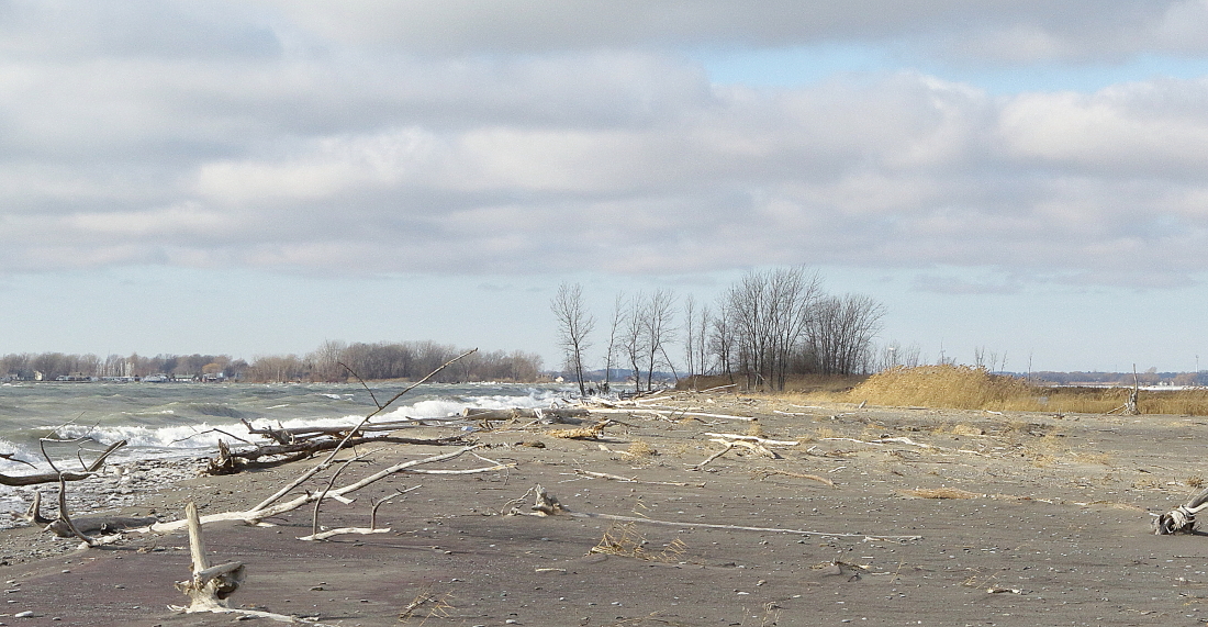
One of the stories of anywhere along the lower Great Lakes of late is the high water and the subsequent erosion. Certainly on a sand spit formation such as Rondeau, the effects are fairly significant. This next photo shows what part of the south beach looked like on the bird count exactly 5 years ago.


Just to finish up a bit about the bird count. I did see a few Tundra Swans flying over the South Point Trail on my way back.


After covering much of the south beach, I checked various other parts of the park that wouldn't have been covered by other bird counters. And then I went to the next major part of my normal territory: the Marsh Trail. In past years, I have driven out to the big parking lot about half way out the Marsh Trail and then walked the rest of the way to the south end, checking out the Long Pond area along the way. However as many readers will know, the Marsh Trail is closed due to being washed away in places, so parts of it are barely passable even on foot at times. The water is down enough to make it more easily accessed on foot, but the trail is officially closed. So instead of driving out, I walked to the parking lot. However with the intensity of the wind, any of the smaller birds that were out there were keeping under cover. Other than a few Bufflehead on the bay and a few Ring-billed and Herring Gulls drifting by overhead, there wasn't much to see. It was a long walk for all I got. I did see this non-birdy thing along the trail, however.

In spite of the overall low numbers of birds, the results were quite satisfying, totalling 102 species at last count. We have only missed hitting the 100 mark three times since 2000, so everyone was pleased with the results. My total for the day was only 34 species, one of the lowest I have ever had, but with the weather being what it was, and the fact that many of the smaller birds left the area with the intense cold spells in the last few weeks, I couldn't complain. But by the end of the day some of my leg muscle were complaining, having walked an estimated 17 kilometres in those conditions and carrying all that gear!
Only three more bird counts to go in the next couple of weeks.

Certainly interesting how that spit has changed and mostly disappeared. I used to walk out there regularly, but miss that now. Not the same anymore!
ReplyDeleteIt certainly does change on a regular basis. I will be doing another post to show some of the flooding and shoreline changes that took place in 1985.
DeleteReally enjoyed this post Allen, because it sent me to google maps satellite view to take a look at the south beach. I enjoy learning a bit about the park landscape as well as the birds. But I couldn't find where the Marsh Trail goes. Even looked up the park website and it doesn't seem to have a map of the trails. Look forward to all your posts. Merry Christmas!
ReplyDeleteThanks, Stew. Sorry for the delay in responding, as this blog site sometimes doesn't let me reply even to my own blog posts!
DeleteThe Marsh Trail starts at the north end of the park, at Water Street, and then is a faint dotted line that more or less follows the edge of the bay/marsh. Hope this helps.