I had considered using the title "The Rise and Fall of the Great Lakes"
for this blog post, as it was the title of an excellent film that we showed to
thousands of kids and adults while I was working at Rondeau. In a very humorous way,
it showed how ice ages and time affected what we know about what changes the
Great Lakes experienced, and why they are like they are today. If you want to see it,
check it out at this link. I watched it again, and can still remember the music, the script, and especially the kids laughter for this production. It was clearly a crowd pleaser! On a much, much smaller scale of time, a similar story has been unfolding at Rondeau for many years.
The existence of Rondeau Provincial Park is due to the water currents of Lake Erie. And that has its highs and lows, both literally and figuratively. It is to be expected as the park is a dynamic sandspit, with parts of it certainly changing seasonally, if not daily. A cross-section of the park clearly shows alternating ridges, formed during periods of high water level, and sloughs, formed during periods of lower water levels. As for the shoreline, that can change very quickly.
Anyone who has been to Rondeau in the last couple of years especially will have images of water-logged and closed trails, a closed campground, and cottages at least partly surrounded by water. We sometimes think the worst, only because our memories may be short. In reality, these types of things have gone on repeatedly to one extent or another.
I was recently rummaging through some slides I took of Rondeau back about 35 years ago, in the mid 1980s. I thought I would scan and share them to put some of Rondeau's relatively recent history into perspective, especially since these last couple of years have had major challenges to anyone living on the waterfront.
This first photo shows the Chatham-Kent Road 15 as it approaches Rondeau. It was taken in April of 1985. The Summer Place campground is just out of view to the right. Note that just before the bridge the water is coming over the road. Just beyond the bridge, on both sides of the road, it is completely open. There is no sign of any vegetation, unlike what it has looked like for the past couple of decades or more. I remember Keith McLean, former owner of what is now the Keith McLean Conservation Lands, telling me that back in the 1930s the land was so dry on the left hand side of that road, he was able to farm it.
My field notes of April 6: ....
very windy, with southwest winds to 90 km/hr......highway at the causeway is covered with water and closed in the morning due to water and debris. North end of the marsh road completely under water; base of the main dock is in danger of being washed away.
This next photo shows the part of the KMCL immediately across the little bridge that crossed the creek on his property. It was taken in about 1995 or 96. The land had been dry for several years, and Keith was interested in creating wildlife habitat, so he had this area planted into tallgrass prairie. The photo was taken from a raised front-end loader of his tractor.
In this next photo, taken in June, 2019, from that little bridge I mentioned above, Keith would have been standing about where the tongue of vegetation sticks out into the several acres of the relatively recently formed lake. The tallgrass prairie has been completely underwater for at least a couple of years, much to the delight of numerous ducks, geese, herons, shorebirds etc.
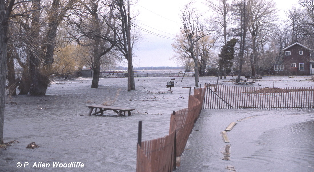
Moving into the park shows a similar theme. These next two photos show the Yacht Club in April 1985. The building is completely surrounded by water, and the water comes almost to the road as the wind-blown water from Rondeau Bay takes over.
I took this next photo just a few days ago. The building doesn't look much different, but it has had some improvements to minimize future flooding. With the high water this past spring, it wasn't quite as bad as what the 1985 photos show, but even now the lawn is still quite soggy from the high water table and some flooding earlier in the season.
Moving a bit farther south, is the last cottage on the bay side, adjacent to the Marsh Trail. Again, these first two photos were taken in April of 1985. There are still some trees on the far side of the Marsh Trail, but the trail itself is barely visible. It is interesting to note that in the second photo, you can see a scraggly remnant of a tree line that extended perpendicularly from the trail. It extended outwards for almost 100 metres, as prior to the early 1970s, the cattail vegetation also extended out that far. For quite a few years now, the tree line and all of the cattail marsh has been destroyed by high water, wave action and ice.
Here is a photo of the same cottage taken just a few days ago. The cottage lot, and the one beside it, was under water for a good part of the first half of 2019, and the lawn was never cut. It is still very soggy.
The Marsh Road is in really rough shape, and on many days one cannot traverse this closed trail without crossing through at least some water.
 |
| Marsh Road, 2019 |
These next two photos show some areas of the cottage community adjacent to Rondeau Bay, the first one being on some slightly higher ground and only covered by sand.
The next one is, appropriately between Water Street and Rondeau Bay. If you look closely (click on the image for a larger view), you can see a small patch of white through the trees slightly to the right of centre. That is the Yacht Club. You may be able to see that the base of the old pier is completely separated from the land. It might be more easily seen in the first photo of the Yacht Club, above.
Flooding was apparent in other areas of the park, although in a different way than what the park experienced in the last couple of years. In 1985, the flooding only lasted for a few weeks, whereas in the last couple of years, it lasted for a few months. In the last couple of years, the flooding was exacerbated by heavy rainfall in the spring which, combined with a very high water table, kept things wet, and resulted in the closed campground for awhile.
Moving to the southern end of the park, it was the same old story, although structures weren't affected this time, as they had been affected as a result of major flooding of 1972-74. This next photo shows the rollers coming in from the lake, washing over the south beach. It was taken in April 1985, from the south end of the Marsh Road.
My field notes of April 10: ....
south beach is washed over for about 350-400 metres, with white caps on the marsh side. The Marsh Road is covered with water in numerous places, sometimes for 100 metres at a time.
The next two were taken from the south beach, also in 1985.
The next shows the south beach taken this past December of 2019. I provided a few shots comparing the south beach of just 5 years ago in a previous blog, which you can
see here.
The following photo, taken in 1985, shows the very southern east/west part of the South Point Trail, which prior to the mid-1970s was a paved road. Note how open it is on the left hand side of the road which is under water. There used to be a fairly sizable parking lot, with room for probably at least 50 cars since it was a popular stopping point for visitors to see the lake. There was also a huge, old style picnic shelter, which disappeared in the early 1970s due to high water and storm damage.
This next photo was taken a few days ago, from much the same vantage point as the previous one. The road is still visible, although the eastern part where I am standing is covered with 20cm or so of sand. Note also that the former parking lot on the left hand side is completely overgrown with shrubbery and small trees. The little bit of it that remains is difficult to walk through.
Even just a few days ago, the western part of the trail still had several centimetres of water on it.
The next one shows the same direction as the previous three photos, taken from the shoreline.
A different perspective, showing the same road, but from the west end, looking toward the vantage point where the previous 4 photos were taken. It was taken in April 2018, showing how much water was over the trail right up to the eastern end where the trail is covered with 20 cm or more of sand.
Due to the regular erosion of the old South Point Trail where the road was washed away and it was difficult to keep it as a trail, a boardwalk was put a short distance inland so hikers, bikers, and strollers would have an easier time of getting from one side to the other.
It was a nice idea, but relatively short-lived. In only a few years, this boardwalk was completely gone, leaving hikers with the only option of getting from one side to the other via the constantly changing beach. And the changes continue, as now the South Point Trail has officially been separated into South Point Trail East and South Point Trail West.
What will the next 35 years bring?


It is very interesting how the the landscape constantly changes. Thanks for sharing those old photos and thoughts!
ReplyDeleteI remember that iconic film "The Rise and Fall of the Great Lakes" from my youth, which I saw several times! Brings back some memories....
Thanks, Blake. I wish I had some good photos of the high water of 1972-73 which flooded out the south campground, and those who were camping there. The Rise and Fall film really made things clearer for kids, and adults too. Definitely the film that was remembered by the most people.
DeleteThanks for another great post Allen!
ReplyDeleteThanks, Brandon...I appreciate your comment.
DeleteFascinating changes!
ReplyDeleteThanks, Mr. FG.....given your background I knew you would appreciate and understand these events.
DeleteA remarkable and valuable study. Terrific photo comparisons to have on record as peoples' memories are so short.
ReplyDeleteLove and blessings.
Thanks, Paula. The photo record is definitely worth portraying from time to time, as we can forget all too easily even in such a short period of time.
Delete