
Today, Dec 11, is International Mountain Day. To those of us living in southern Ontario, and particularly southwestern Ontario, to most of us flat-landers, mountains are only a thing of the imagination. The highest things to be seen in this part of the province are landfill mounds!
Mountains are critically important, however. Most are either in the west or eastern parts of this continent, and have had a great influence on many aspects of the continent's weather patterns and thus the productivity of the land in between. And given that due to the elevation, different vegetation zones exist, they can be very diverse.
According to the Canadian Mountain Network,
-85% of the world's birds, mammals and amphibians live in mountain habitat;
-25% cent of terrestrial species call mountains, home;
-60-80% of all freshwater resources come from mountain sources;
-50% of the world's biodiversity hot spots occur in mountains.
Pretty impressive, isn't it.
I've been fortunate to have taken many trips to mountainous areas here in North America, from the Appalachians in the east, to the southwestern mountain regions of Arizona, and to many of the various mountain regions of the western US and Canada. I would like to highlight a small number of the more impressive places I have seen in some those travels. Note: in numerous trips up until the early 2000s, all of my photos were taken on film, mostly Kodachrome, so quite a few of the ones shown here have been scanned. They aren't quite as good as the originals, but the scanner overall did a fairly good job.
The mountains in the east are certainly less rugged than their counterparts of the west. There is often a blue haze in the distance, especially in portions of the Appalachian chain. This is especially the case during the summer and autumn, explaining how Great Smoky Mountain National Park got its name.


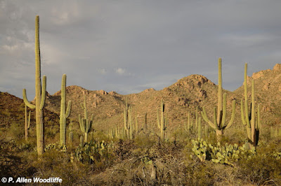
In the extreme southwestern part of the USA, the mountains may not be any higher than most in the Appalachians. Due to the aridity, they are exposed due to the lack of vegetation and therefore show off their rugged nature. Many of the mountain ranges in southeastern Arizona actually are a northern part of their range originating in Mexico. They are sometimes referred to as the Mexican mountains, and some of the bird species that have their main range in Mexico, may move into Arizona since the birds don't recognize international boundaries :-).
 |
| Chiricauhua Mountains |


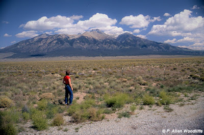
Going more or less northward from Arizona eventually gets you to Colorado, where some of the Rocky Mountains are at their best. There are various mountain ranges within the overall Rocky Mountain chain.
This first one is at Great Sand Dunes National Park. Historically when the land dried up, the prevailing southwesterly winds blew the sand to the northeast, but couldn't get the sand over these Sangre de Christo mountains, so just kept building upwards. Some of the sand dunes are over 700' high, the highest in North America.


North of here, and almost within sight of Denver, is Rocky Mountain National Park, which Marie and I first visited in 1982. While parts of the park, especially as one approaches it, looks appealing, it shows hints of what is to come with the treeless mountains in the background.

Much of the park is above the treeline. The Trail Ridge Road, where it crosses the continental divide, is 12,183' (~3713 metres) in elevation. There is a trail here, and we got out to explore it a bit, but we hadn't acclimatized to the increase in elevation and so even walking slowly along the trail got us huffing and puffing in short order.


Northwest of Rocky Mountain NP and immediately south of Yellowstone is another iconic place: Grand Teton National Park. This area immediately adjacent is where the city of Jackson came to be, the name taken from Jackson Hole. Jackson Hole was where in the 1800s when beaver trapping was in its hey-day, trappers and mountain-men met here at an annual rendezvous, to sell their furs, socialize and stock up for their next season of trapping.


In Alberta, the famous duo of mountain parks occur: Banff and Jasper. Banff is the oldest national park in Canada, being established in 1885. There is no question about the popularity world wide of these two, especially Banff, as when you go, it seems like you are in a different country with the dominance of all the foreign languages heard.
Mount Rundle, shown first, is certainly a well-known part of the Banff mountainscape.....


Jasper NP doesn't get quite the same publicity as Banff, but is impressive in its own right. Besides the icefields, there are numerous views such as this one.....


A bit further southwest, in southeastern British Columbia, is the Kootenay Range. At times, they can look quite foreboding, such as this view of the mountains near Kaslo.....


The first time was in the fall of 1985. As we approached one of the main entry points, this is the first view point.

We descended to the valley floor and this is the view from that level, showing the Merced River quietly meandering along the floor. Famous land marks such as El Capitan, on the left, and the Cathedral Spires on the right were easily visible.

One of the pieces of music played on John Muir's High Sierra was the Canon de Pachelbel in D major. We purposely took a tape of that music, and for at least half an hour or so, we drove slowly around the valley floor, listening to that music and taking in the spectacle. Our conversation was almost non-existent except for numerous oohs and aahs. It was truly one of the most inspirational times we have ever had in our many travels. Here is a great version of this music.
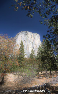 |
| El Capitan |
 |
| The Three Brothers |

 |
| Liberty Cap |

As impressive as Yosemite is, another valley just a short way upstream from Yosemite that was impressive in its own way, was lost to 'progress' in the early 1900s. It was known as the Hetch Hetchy Valley, and was damned in order to be a source of fresh drinking water piped to the city of San Francisco. There are efforts to reclaim the Hetch Hetchy, and with the ongoing efforts put forth via International Mountain Day and others, perhaps at some point its beauty will be revealed once again.
Happy International Mountain Day!
If you would like to subscribe, or unsubscribe to Nature Nuggets, send an email to prairietramper@gmail.com
Well you learn something new every day! That brought back a lott of wonderful memories. Thanks.
ReplyDeleteThanks, Furry. It did give me a chance to go through a lot of slides from yesteryear, and was fun to re-live so many pleasant times.
Delete