Showing posts with label Erieau Pier. Show all posts

Friday, 29 October 2021

Forest changes, some new locations for an endangered species, and lots of wave action

 This is the time of year when some of the more dramatic changes on the landscape occur. Late October through November is when the longest and strongest winds occur, and in combination with the continuing drop in temperature, the changes in forest vegetation are quite noticeable. As the chlorophyll in the leaves retreats up the stem, the normally less dominant colours of other elements in the leaves become visible. Red, yellow and orange will be more evident, until they turn brown, and then are blown off. 

It is one of my most favourite times of year, even with the shorter day length to contend with. Natural areas are preparing for their winter senescence. Natural areas are less crowded, and one can enjoy the changes.

I've been out to Rondeau and elsewhere a few times over the last several days. Most recently it was on one of the windiest days of the fall to date, and with a predominant east wind. Walking the trails, shuffling through some of the fallen leaves, and listening to the waves roar is inspiring, at least to me. This photo of the east beach was taken this past Thursday.

I had decided to walk some of the inland roads and trail where it wasn't all that windy, but the roar of the waves was in high gear. Birds inland were not plentiful, but included the normal inhabitants: Red-bellied Woodpecker, Golden-crowned Kinglet, Black-capped Chickadee, etc. Perhaps if I had spent some of the time 'scoping the waterfront, I might have come across some of the uncommon species that others saw from nearby shorelines. Maybe next time. 

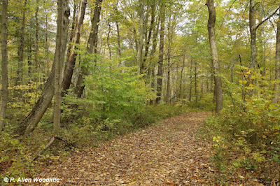
The following photo was taken on Oct 28, showing a bit of change from the next photo, which was taken not quite three weeks earlier, on Oct 8. In some years, most of the leaves have already turned colour and/or fallen by now, but the warm, damp weather that has been the norm over the past few weeks has delayed that process. I expect much bigger changes in the next week or so.


As a further comparison, this next one was taken on Oct 26, 2015.


  These next two were taken along Harrison Trail, the first one being on Oct 28 while the second one was taken in late September at almost the same vantage point.


This is normally the best time of year to find an endangered species: Red Mulberry. Red Mulberry is mainly limited in its Canadian range to places like southern Essex County (Pelee Island and Point Pelee NP), Rondeau and some parts of the Golden Horseshoe at the east end of Lake Erie. There are very few individuals elsewhere, but a few. 

I hadn't been intentionally looking for them on this day, but always keep an eye open for them when the forest gets to this stage. I hadn't found any new ones in the last couple of years, so I was surprised to find not one, not two, but four and a half new ones! Yes, one was only a half a Red Mulberry in my opinion. While it showed very large leaves with some good drip tips, they were heavily lobed, as the next photo shows. Lobing does occur in Reds, but is more typical of the non-native White Mulberry, and there are quite a few Whites scattered around the park, especially on the east side. The lower leaves, also heavily lobed and much smaller, did not seem to have much in the way of pubescence on either the upper or lower surfaces, a sure sign of hybridization, although some of the pubescence may not be as evident as during the peak of the growing season. Most definitely I will have to take a closer look at this tree next year.

The leaves shown here are more typical of Red Mulberry: very large, almost small dinner plate size, with an occasional lobe but often none. Also they have quite obvious drip tips. It is my understanding that because the leaves of the Red Mulberry have pubescence on the surface, it holds moisture from any precipitation, and therefore can be more susceptible to mould and mildew. The weight of the moisture trapped by this pubescence causes the leaves to droop, and run off on the drip tip, reducing the likelihood of such mould and mildew build-up, and hence a healthier tree.

I also spent a bit of time at Erieau, as one never knows what might show up during the autumn migration. Perhaps the Harlequin Duck, scoters or Black-legged Kittiwake would make Erieau a rest stop. All of those have been here before. I didn't see any of those on this visit, but did encounter a small number of lingering Sanderling.

A Lesser Black-backed Gull, not a common, but regular species and probably about a third-cycle bird, was resting on the pier with the more abundant gull species.

On the windiest day of my periodic visits to Erieau, I purposely went in order to capture some photos of the waves crashing over the pier. It was well worth the effort, but took care trying to shield my camera from the spray of water and sand.


Some of the wave sprays must have gotten as high as 10 metres or more above the pier. It was not a time to be venturing out on the pier! Some had done this many years ago, and came to a tragic end.

 It isn't quite as dramatic as what Lake Superior must have been like when the Great Lakes freighter Edmund Fitzgerald went down to the bottom with all hands lost, but even this is certainly a demonstration of the power of moving water, and how it can shape the shoreline. Rondeau, as a sandspit peninsula, is all about such wind, wave and water currents that formed it over many centuries.

 In some of my other travels of late, I came across a couple of new locations for Pawpaw. It is officially a Very Uncommon species in Ontario and Canada, although for some reason, Chatham-Kent has a significant segment of the overall population. These two clusters were fairly close together in the vicinity of Clear Creek Forest Provincial Park.

I also came across this rather large individual of Black Gum, another officially Very Uncommon species in Ontario and Canada. This is the only naturally occurring one that I know of in Chatham-Kent and is located a bit southeast of Thamesville. Using a clinometer, I measured it to be about 25 metres high. I didn't try and measure the diameter at breast height with my diameter tape, as the trunk was covered with many poison ivy vines, but I estimated it to be almost a metre in diameter. I had checked on this tree a couple of weeks ago, and although there was some nice deep red colour in the leaves, the sky was very bland, so I waited for a sunnier, brighter day. Alas, many of the leaves by this time had fallen off.

Enjoy the autumn colours while they last!


If you would like to subscribe, or unsubscribe, to Nature Nuggets, send an email to prairietramper@gmail.com


Friday, 5 July 2019

Birds, butterflies and orchids, mostly in Chatham-Kent

I haven't gone too far these last few days, but enough to find some interesting things.

Dickcissels are around again, but not in nearly the numbers of 2017, nor in 2018. I had found a few at the Dealtown Crown Land prairie both of those years, and have been there twice this year.  I had a good variety of shrubby/grassland birds as well as aerial insectivores, some of which gave me some good photo ops, but no Dickcissel.

Bank Swallows were quite abundant, not surprising though since this site is only about a kilometre from Lake Erie where the steep clay cliffs often have this species nesting in.
Bank Swallow


 No Bobolinks this year either, but a couple of Eastern Meadowlarks are there.
There are some early southern-bound shorebird migrants. Usually the local sewage lagoons are the places to find them, and there is a very small number there, but with all of the flooded fields to choose from, they will be spread out wherever there is shallow water. Lesser Yellowlegs are the more common shorebird so far, although a few others have also shown up.
 I've checked the flooded fields along Lagoon Road where a lingering Franklin's Gull has been seen on occasion, but I did not catch up to it. There were Lesser Yellowlegs and lots of Killdeer. A few of the typical summering gulls were around, as well as a few Caspian Terns.
 The Blenheim lagoons have good conditions for shorebirds, but except for lots of Killdeer and a few Lesser Yellowlegs, the shorebirds have not made a point of hanging out there yet. But there are a few other waterbirds, including a few Ruddy Ducks, this pair of Blue-winged Teal....
....and a Ring-necked Duck. There had been a pair of Ring-necks not that long ago, but the male was not visible on this visit.
I stopped at Erieau on one occasion. As has been the case throughout the spring, the water continues to be very high. The pier gets washed over periodically, even when there is very little wave action.
 On the vegetated part of the beach dunes, the Common Hop-tree is in full flower. It is Special Concern, one notch lower than Threatened under the Endangered Species Act.


Of course I managed to get to Rondeau a couple of times. Birds have been fairly typical, just the usual breeding species or vagrants. American Redstarts are scattered about the forest.
 A couple of pairs of Prothonotary Warblers continue along the Tuliptree Trail. I can never get enough of these critters!


While watching the Prothonotaries for awhile, this Green Frog was plinking like a banjo string in the slough nearby. It is surrounded by a plant called Frog-bit, which is not native to North America but arrived several decades ago. It was first discovered at Rondeau in 1976 when I was out canoeing in the Rondeau marsh with my university Aquatic Vascular Plants professor. It has expanded at Rondeau considerably since then, being found almost anywhere there is some sunny, quiet water.
The White-winged Dove continues along Lakeshore Road, south of the Visitor Centre. The stainless steel chimney at 17168 continues to be a favourite hang-out.
Earlier in the week I was out to show some friends a small population of Puttyroot, an orchid they had never seen before. The Puttyroot had finished flowering and had developing seed capsules. But before these folks left the park, they checked out a couple of trails and came across another orchid: Ragged-fringed Orchid. It is not a common species anywhere, but can be found in wet woods and sometimes in wet grassy meadows. This particular individual was at the base of a tree in a slough. I had access to a pair of hip waders to get close enough for these photos.


On one occasion I ventured beyond the boundaries of Chatham-Kent. Fellow blogger Blake had reported that the Oak Hairstreaks had appeared at the Reid Conservation Area in southern Lambton, so one partly sunny and very hot morning I headed there. There were lots of European Skippers, several Banded Hairstreaks, and at least two Oak Hairstreaks.


Banded Hairstreak

Oak Hairstreak
The butterflies were not as prevalent as they often have been for the time of year, so it will be interesting to see if the upcoming butterfly counts show this trend or not.


Saturday, 24 February 2018

Positives and negatives of all that rainfall

There is no question that the last few days have had many people concerned in the Great Lakes Region. With the warm weather and substantial amounts of rainfall quickly melting the snow pack, there is a lot of water on the landscape!

I've been up along the St. Clair River a couple of times recently, partly hoping to see the King Eider that had been hanging around the north end of Stag Island for a few days. I didn't catch up to it, but saw lots of other waterfowl. The warm weather and rainfall has certainly cleared out a lot of the ice.

A Horned Grebe, hanging out in the vicinity of the Chenal Ecarte at the bridge that goes to Walpole Island First Nation was a bit of an early arrival.
 Common Mergansers were quite common.
 There was the occasional Hooded Merganser.
 Long-tailed Ducks used to be a novelty on this river, but for the last decade or so, have become much more common. Several hundred, sometimes more, are scattered somewhere along the river on any given day.
 Red-breasted Mergansers aren't as abundant as their Common relatives, but a few can be found.
 Redheads are frequently seen, sometimes in large rafts.
Canvasback are reliably seen, although this year they haven't been nearly as common as Redhead.

I saw three Bald Eagles also, all immatures, but not well enough to try for a photo. A Great Blue Heron flushed up from a warm water outflow just south of Bickford Line. No photo there either.

While driving south along the river, I looked over at the edge of a woodlot which belongs to the family of a friend. I knew Wild Turkeys hung out there, as it is within my usual territory for the Christmas Bird Count. Sure enough there were a couple of dozen roaming around in the field just beyond the woods.


With all the rainfall, I knew that the McKeough Floodway would be in use. It was constructed in 1984 in response to the major flooding that Wallaceburg often experienced. The floodway re-directs excess water from the East and North Sydenham Rivers before it gets to Wallaceburg, thereby alleviating some of the flood risk. Sure enough, there was a lot of water flowing through the floodway and entering the St. Clair River safely away from Wallaceburg.
Floodway looking 'upstream' from Baseline Road
 After viewing the floodway I returned home via West Holt Road heading over to Hwy 40. I was pleased to see a Snowy Owl sitting cooperatively on top of a hydro pole, which allowed me to get some reasonable shots.
Upon arriving home on one of these occasions, before all the snow had disappeared, I was surprised to see Am Robins hanging out in our yard. At least a dozen were there, taking turns searching in the leaves near the base of the house which hadn't been covered with snow. They hung around for several days until most of the snow was gone, scattering to other snow-free areas.


Waterfowl were arriving in greater numbers in the vicinity of St. Clair NWA, as expected. I checked them out and saw many of the usual overwintering species, but caught up with Snow Geese and Greater White-fronted Geese as well, although they were too far away to bother with a photo. I did capture these Northern Pintail, however. The occasional one had been around all winter, as had Gadwall, Green-winged Teal and Am Wigeon, but there was definitely an influx of them in the last few days.
The flooded fields were very attractive to waterfowl.

They were much less attractive to the farming community. This part of Chatham-Kent is extremely flat, due to the outwash of receding glaciers a long time ago. This highly productive area dominated by rich black soil is a result of the wetland or prairie vegetation that developed here after the glaciers left. If the water levels of adjacent Lake St. Clair was high, it would be wetland; in periods of lower water level, it would be dominated by wet tallgrass prairie vegetation. But it has very poor natural drainage, so farmers do everything they can to remove standing water as quickly as possible. Pumping stations are strategically located, and in these last few days every one of them has been in operation where tractor powered pumps are going full tilt pumping the water off the fields, through the tile drains, and emptying the offending liquid into the larger drain system.
 This particular photo was taken along Town Line Road and empties into Lake St. Clair at St. Luke's which is the north end of Town Line Road.

The Erieau area is always worth checking out due to the wetlands and waterfront there. Again, this time of year waterfowl are the most abundant bird species. It wasn't many days ago where the extensive ice conditions limited open water to these birds. The main channel often had a bit of open water.
A lone Gadwall was there, hanging out in the vicinity of Am Black Ducks.

A four-legged Mute Swan?
On one of the warmer days I was there, the fog had rolled in making views much more challenging, so I opted for a different kind of photography.

I did see some waterfowl resting and feeding in the wet fields adjacent to McGeachy Pond just outside of Erieau. The fog wasn't quite as thick, but still made viewing and photography challenging. I got these three Greater White-fronted Geese under much less than ideal conditions.


On the way home I decided to check out the Indian/McGregor Creek diversion that protects the south end of Chatham from flooding. It is much smaller than the McKeough Floodway mentioned earlier, but the Indian/McGregor Creek watershed is much smaller than the combined East and North Sydenham Rivers. It wasn't that many decades ago when residents of south Chatham greatly feared the weather conditions we have been experiencing these last few days, as late winter and early spring flooding was almost a regular event. There hasn't been any serious flooding in that area since 1992 when this floodway project was completed. This first image shows McGregor Creek at the corner of Hwy 40 and Boundary Line, looking south. The creek at this point is normally less than 5 metres wide at the bottom with only a little water flowing. Here it is probably well over 100 metres wide.
 This next photo shows McGregor Creek at the corner of Maynard Line and Creek Road. It clearly looks more like a small lake than a creek!
Flooding to some extent does still occur in the immediate area of downtown Chatham. Here is an impressive aerial video of downtown Chatham taken today, Feb 24 just before peak water levels of the Thames River arrive. This video has now been taken down by the owner, unfortunately. But this one shows another section of the river flood downstream from the downtown.