Showing posts with label erosion. Show all posts

Thursday, 16 January 2020

The Highs and Lows of a Sandspit

I had considered using the title "The Rise and Fall of the Great Lakes" for this blog post, as it was the title of an excellent film that we showed to thousands of kids and adults while I was working at Rondeau. In a very humorous way, it showed how ice ages and time affected what we know about what changes the Great Lakes experienced, and why they are like they are today. If you want to see it, check it out at this link. I watched it again, and can still remember the music, the script, and especially the kids laughter for this production. It was clearly a crowd pleaser! On a much, much smaller scale of time, a similar story has been unfolding at Rondeau for many years.
 
The existence of Rondeau Provincial Park is due to the water currents of Lake Erie. And that has its highs and lows, both literally and figuratively. It is to be expected as the park is a dynamic sandspit, with parts of it certainly changing seasonally, if not daily. A cross-section of the park clearly shows alternating ridges, formed during periods of high water level, and sloughs, formed during periods of lower water levels. As for the shoreline, that can change very quickly.
Anyone who has been to Rondeau in the last couple of years especially will have images of water-logged and closed trails, a closed campground, and cottages at least partly surrounded by water. We sometimes think the worst, only because our memories may be short. In reality, these types of things have gone on repeatedly to one extent or another.

I was recently rummaging through some slides I took of Rondeau back about 35 years ago, in the mid 1980s. I thought I would scan and share them to put some of Rondeau's relatively recent history into perspective, especially since these last couple of years have had major challenges to anyone living on the waterfront.

This first photo shows the Chatham-Kent Road 15 as it approaches Rondeau. It was taken in April of 1985. The Summer Place campground is just out of view to the right. Note that just before the bridge the water is coming over the road. Just beyond the bridge, on both sides of the road, it is completely open. There is no sign of any vegetation, unlike what it has looked like for the past couple of decades or more. I remember Keith McLean, former owner of what is now the Keith McLean Conservation Lands, telling me that back in the 1930s the land was so dry on the left hand side of that road, he was able to farm it.

My field notes of April 6: ....very windy, with southwest winds to 90 km/hr......highway  at the causeway is covered with water and closed in the morning due to water and debris. North end of the marsh road completely under water; base of the main dock is in danger of being washed away.
 This next photo shows the part of the KMCL immediately across the little bridge that crossed the creek on his property. It was taken in about 1995 or 96. The land had been dry for several years, and Keith was interested in creating wildlife habitat, so he had this area planted into tallgrass prairie. The photo was taken from a raised front-end loader of his tractor.
 In this next photo, taken in June, 2019, from that little bridge I mentioned above, Keith would have been standing about where the tongue of vegetation sticks out into the several acres of the relatively recently formed lake. The tallgrass prairie has been completely underwater for at least a couple of years, much to the delight of numerous ducks, geese, herons, shorebirds etc.

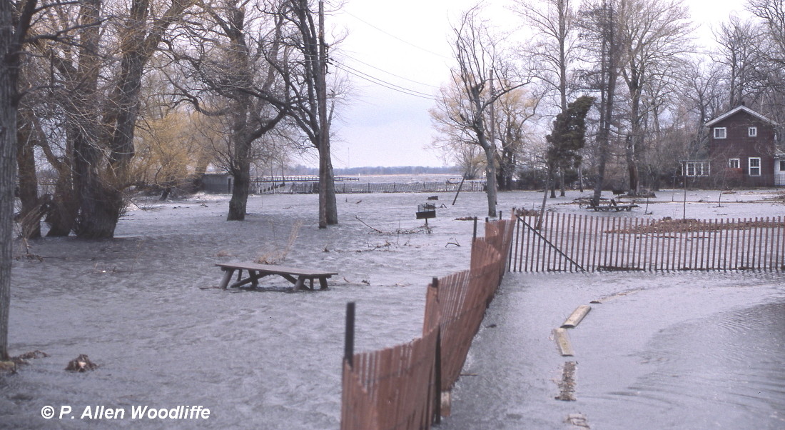
Moving into the park shows a similar theme. These next two photos show the Yacht Club in April 1985. The building is completely surrounded by water, and the water comes almost to the road as the wind-blown water from Rondeau Bay takes over.

 I took this next photo just a few days ago. The building doesn't look much different, but it has had some improvements to minimize future flooding. With the high water this past spring, it wasn't quite as bad as what the 1985 photos show, but even now the lawn is still quite soggy from the high water table and some flooding earlier in the season.
Moving a bit farther south, is the last cottage on the bay side, adjacent to the Marsh Trail. Again, these first two photos were taken in April of 1985. There are still some trees on the far side of the Marsh Trail, but the trail itself is barely visible. It is interesting to note that in the second photo, you can see a scraggly remnant of a tree line that extended perpendicularly from the trail. It extended outwards for almost 100 metres, as prior to the early 1970s, the cattail vegetation also extended out that far. For quite a few years now, the tree line and all of the cattail marsh has been destroyed by high water, wave action and ice.

 Here is a photo of the same cottage taken just a few days ago. The cottage lot, and the one beside it, was under water for a good part of the first half of 2019, and the lawn was never cut. It is still very soggy.
The Marsh Road is in really rough shape, and on many days one cannot traverse this closed trail without crossing through at least some water.
Marsh Road, 2019
 These next two photos show some areas of the cottage community adjacent to Rondeau Bay, the first one being on some slightly higher ground and only covered by sand.
 The next one is, appropriately between Water Street and Rondeau Bay. If you look closely (click on the image for a larger view), you can see a small patch of white through the trees slightly to the right of centre. That is the Yacht Club. You may be able to see that the base of the old pier is completely separated from the land. It might be more easily seen in the first photo of the Yacht Club, above.
Flooding was apparent in other areas of the park, although in a different way than what the park experienced in the last couple of years. In 1985, the flooding only lasted for a few weeks, whereas in the last couple of years, it lasted for a few months. In the last couple of years, the flooding was exacerbated by heavy rainfall in the spring which, combined with a very high water table, kept things wet, and resulted in the closed campground for awhile.

Moving to the southern end of the park, it was the same old story, although structures weren't affected this time, as they had been affected as a result of major flooding of 1972-74. This next photo shows the rollers coming in from the lake, washing over the south beach. It was taken in April 1985, from the south end of the Marsh Road.

My field notes of April 10: ....south beach is washed over for about 350-400 metres, with white caps on the marsh side. The Marsh Road is covered with water in numerous places, sometimes for 100 metres at a time.
 The next two were taken from the south beach, also in 1985.

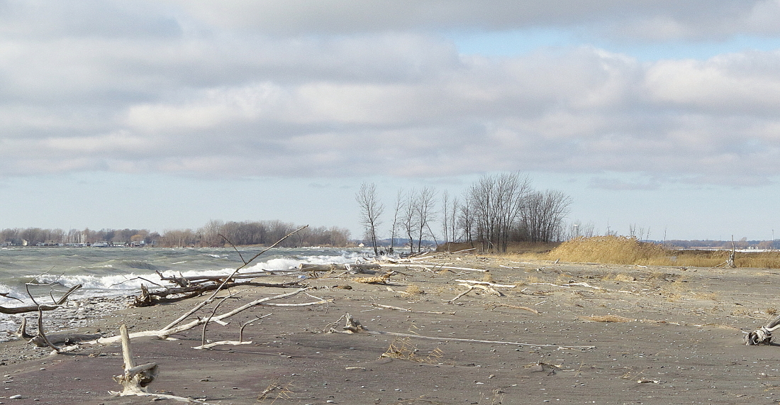
 The next shows the south beach taken this past December of 2019. I provided a few shots comparing the south beach of just 5 years ago in a previous blog, which you can see here.
 The following photo, taken in 1985, shows the very southern east/west part of the South Point Trail, which prior to the mid-1970s was a paved road. Note how open it is on the left hand side of the road which is under water. There used to be a fairly sizable parking lot, with room for probably at least 50 cars since it was a popular stopping point for visitors to see the lake. There was also a huge, old style picnic shelter, which disappeared in the early 1970s due to high water and storm damage.
 This next photo was taken a few days ago, from much the same vantage point as the previous one. The road is still visible, although the eastern part where I am standing is covered with 20cm or so of sand. Note also that the former parking lot on the left hand side is completely overgrown with shrubbery and small trees. The little bit of it that remains is difficult to walk through.
 Even just a few days ago, the western part of the trail still had several centimetres of water on it.
 The next one shows the same direction as the previous three photos, taken from the shoreline.
 A different perspective, showing the same road, but from the west end, looking toward the vantage point where the previous 4 photos were taken. It was taken in April 2018, showing how much water was over the trail right up to the eastern end where the trail is covered with 20 cm or more of sand.
 Due to the regular erosion of the old South Point Trail where the road was washed away and it was difficult to keep it as a trail, a boardwalk was put a short distance inland so hikers, bikers, and strollers would have an easier time of getting from one side to the other.
It was a nice idea, but relatively short-lived. In only a few years, this boardwalk was completely gone, leaving hikers with the only option of getting from one side to the other via the constantly changing beach. And the changes continue, as now the South Point Trail has officially been separated into South Point Trail East and South Point Trail West.
What will the next 35 years bring?

Thursday, 19 December 2019

Blenheim/Rondeau Christmas Bird Count: my perspective

Bloggers like to tell stories about the exciting things they saw or did recently. Otherwise, why write, right? So when my recent day on the Blenheim/Rondeau Christmas Bird Count was one of my less exciting days on this count, I wrestled with what to say about it. But the more I thought about it, the more I decided there were things that were important to share even if there weren't lots of exciting birds. No White-eyed Vireo or Barred Owl, like last year.

If memory serves me correctly, and as one ages that is less and less likely to happen, I have participated on this particular count for almost exactly 50 years. My first few years were with my dad covering farmland and woodland outside the park, not far from the farm where I grew up. Once my career began with Rondeau in the early 1970s, my territory to cover was park based. And for about the last 35 years or so, it has included some of the most remote parts of the park.

My starting point is at the south end of the South Point Trail, and striking off along the south beach intending to go all the way to the Erieau channel. It is one of my favourite parts of the park, but it can be quite challenging in winter. While this past count day was not the worst conditions I have had to put up with, it was not exactly easy. The temperature wasn't that bad, being just below freezing, but the wind was quite brisk. The trek out was facing straight into the wind which varied between 30-45 km/hr, and the south beach is quite exposed.


Last year I had two friends join me, and they were intending to join me again this year, but on my way out to the park that morning, I got a text stating that due to some health conditions they were not quite over, they would not be making the trek to Rondeau for the count. So I was on my own. That put me at an immediate disadvantage since more eyes are better, and their younger eyes and ears would be very helpful in pin pointing any little bird that was out there. However given the constant noise due to the wind and wave action, I suspect that even their ears wouldn't have been able to hear any birds.

It can be a little risky on the south beach. The first part of the area has very spotty cell service, so if you run into a problem, you are on your own. Cell phones and being able to be in touch with the world at any given moment is a relatively recent phenomenon, of course. It wasn't that long ago that you just ventured out into the wild with no contact and never gave it much thought. How the technological aspects of our times have changed.

At any rate, out I went. I didn't take my camera with me, as I was already loaded down with binoculars, scope, and a few snacks in my heavy winter parka. I scanned the lake regularly with both binoculars and scope, hoping for some goodies such as Red-throated Loon. While that species was seen in much smaller numbers this year compared to last, it seemed that all were along the east beach, and instead of following the shoreline, kept going south and not within my view.

There was an average diversity of waterfowl and gulls, but nothing all that unexpected. The best bird I got was a Green-winged Teal which turned out to be the only one on the count. There were some hunters at the far end of the tip, presumably along the sheltered side of bay/marsh, so I didn't go all the way. I did scope as far as I could see and there weren't any ducks at the end.

One of the stories of anywhere along the lower Great Lakes of late is the high water and the subsequent erosion. Certainly on a sand spit formation such as Rondeau, the effects are fairly significant. This next photo shows what part of the south beach looked like on the bird count exactly 5 years ago.
This is looking towards Erieau. The grasses are predominantly Little Bluestem, a pioneering grass species often found on beach dunes. Fast forward to 2019, and this next photo is what it looks like today, more or less from the same vantage point.
As stated earlier, I didn't have my camera with me on the day of the count, so I decided to go out again today and leave my scope in the vehicle and take my camera instead. It was a bit colder today, and every bit as windy. There was a bit of ice forming along the shoreline, and the bay was totally frozen over. But if I am dressed for the weather and prepared, I really enjoy getting out into the elements to see the forces of nature at work on this dynamic sand spit. Go out regularly and the changes are subtle. But comparing photos over a longer period of time, and it is really evident there are some major changes. This next photo is at the beginning of the break in the south beach that was evident for quite awhile earlier in the year. It was probably the most extensive break in this narrow south beach that I have ever come across in my 50 or so years of exploring this feature. The distance between where I took this photo, and the trees at the far end of the sand spit that locals call "Gull Island" but which really isn't an island, is probably almost a kilometre.
This portion of the south beach has been migrating northward for well over a century. At one point the Erieau part of the peninsula and the Rondeau part of the peninsula were in alignment. The only thing that separated them was the channel at Erieau. Since boat access to Rondeau Bay was important back in the day, a pier was constructed at Erieau in the late 1800s. And that began the changes. The prevailing water currents came from the west, and when they encountered the pier, slowed down and dropped their load of sand, slowly building up the west side which is now known as Laverne Kelly Memorial Park. But when the water currents got around the end of the pier and continued eastward towards the south beach, the resumed velocity caused the currents to pick up sand and move it either along the shoreline, or moved it northward, into Rondeau Bay. It is interesting that a geological consultant in the early 1970s determined that part of the south beach a bit east of Erieau had moved northward ~550 feet from the early 1930s to the early 1970s. With the continued high water level, less ice to protect the shoreline and increase in wave action, it is clear that the south beach has moved quite a bit farther north in the last 40+ years. This next photo was one I took in April, 1989. It shows how even at that time, the Erieau sand spit on the left of the pier had developed so much farther south than the south beach side, on the right. I wish I had taken one just a little farther east, showing how much the south beach curved northward at the time.

While my main intent of today's trip was to capture shots of the south beach to compare it with 5 years ago, I took advantage of some other winter type scenes.

 The ice is really starting to build up on the fallen trees along the shoreline. But with the warmer weather forecast until after Christmas, I expect this new ice will be short lived.

Just to finish up a bit about the bird count. I did see a few Tundra Swans flying over the South Point Trail on my way back.
At the end of the day, I came across a flock of about 350 swans scattered across a field just north of Hwy 3/Talbot Trail.
An Eastern Screech Owl is periodically seen in a cavity of an American Beech tree along Bennett Ave, although it is often only partially visible.
One thing of interest I noted a couple of days before the count was this Northern Brown Snake lying along the north section of Rondeau Road.
It didn't have a mark on it that was noticeable, but it was very dead. Perhaps a bicycle went over it, or perhaps it just succumbed to the cold. It was still there today.

After covering much of the south beach, I checked various other parts of the park that wouldn't have been covered by other bird counters. And then I went to the next major part of my normal territory: the Marsh Trail. In past years, I have driven out to the big parking lot about half way out the Marsh Trail and then walked the rest of the way to the south end, checking out the Long Pond area along the way. However as many readers will know, the Marsh Trail is closed due to being washed away in places, so parts of it are barely passable even on foot at times. The water is down enough to make it more easily accessed on foot, but the trail is officially closed. So instead of driving out, I walked to the parking lot. However with the intensity of the wind, any of the smaller birds that were out there were keeping under cover. Other than a few Bufflehead on the bay and a few Ring-billed and Herring Gulls drifting by overhead, there wasn't much to see. It was a long walk for all I got. I did see this non-birdy thing along the trail, however.
I'm not sure what the intent of this wildlife cam was, but I got a photo of it taking a photo of me, if in fact it was working.
In spite of the overall low numbers of birds, the results were quite satisfying, totalling 102 species at last count. We have only missed hitting the 100 mark three times since 2000, so everyone was pleased with the results. My total for the day was only 34 species, one of the lowest I have ever had, but with the weather being what it was, and the fact that many of the smaller birds left the area with the intense cold spells in the last few weeks, I couldn't complain. But by the end of the day some of my leg muscle were complaining, having walked an estimated 17 kilometres in those conditions and carrying all that gear!

Only three more bird counts to go in the next couple of weeks.


Saturday, 19 October 2019

Rondeau Ramblings and a bonus Purple Sandpiper!

Earlier this week I went for a long walk along the west side of the South Point Trail. The colours are starting to change, and the much cooler weather of the last few days will likely hasten the colour changes along.
The birds were fairly few and far between, and the only one I managed to photograph was this juvenile Northern Harrier.
A goal for this little trek was to get to the lake and see what the conditions were like at the south end, for future black lighting considerations. There are some possibilities but probably not until next year.

The south end of the park has continued to experience major changes due to the high water. I was greeted by this scene at one point. For those readers with long memories, the concrete structure is the remains of a washroom that at one point in my memory was probably at least 150 metres from the shoreline. This is not the first park structure to end up in the lake. There was a large picnic shelter that was between the south point parking lot and the lake, which even as far back as the mid 1970s had ended up in the lake. The parking lot is gone as well.

 If you look closely at the second photo above and on the left you may see a pile of rocks. That was the old septic holding tank which, after the washroom was closed down, was filled with rocks partly to keep it safe from people falling into it, and partly because some species of snakes may decide to use it as a hibernaculum for the winter.
The South Point Trail used to go all the way around, but the next photo shows what a significant section of the trail has ended up like, with all of the erosion and fallen trees. As a result, the new  signs at the beginning of each side indicate that they are considered to be two distinct trails with no meaningful connection. There is now a South Point Trail East and South Point Trail West


 American Beech trees are normally found in the interior of the forest. Here is a beached, American Beech in the next photo and looks totally out of habitat.
 In spite of all of the erosive action during the highest water levels and strongest wind and wave action, there is some fairly open beach that has re-formed. With November being one of the windiest months of the year, however, who knows how long this will last.
Today, Steve Charbonneau put the word out that a Purple Sandpiper was along the east beach of Rondeau just south of the traffic circle (thanks, Steve!). Purple Sandpipers are quite irregular along the lower lakes. We used to see them every year or so, but in the last few years, they have been really hard to find anywhere. Having said that, I came across one at the base of the Erieau pier last January. It only stayed for a few hours, and only 4 of us got to see it. That was only about the third record in Ontario for the previous 4 months. The bird today was much more available for viewing.

It remained in the same general stretch of beach from about 10 a.m., when Steve first discovered it, until at least 5:30 p.m. Birders and bird photographers were very happy with the conditions and the cooperation of the bird.
A common question from some birders I was talking to was why the bird was so tame. This bird appears to be a first year bird, and the species nests in the high arctic. It is quite possible that, depending on the route it took to get here, the humans it saw today might have been the first ones it had seen, and didn't know whether to be wary or not. Regardless, it was very cooperative and the lighting was excellent.

Sandpiper yoga?

Jumping an arriving wave

The Keith McLean Conservation Lands continues to be attractive to migrating water birds, and a half dozen or so species of shorebirds can usually be found with a little effort.
Greater Yellowlegs
Lesser Yellowlegs
Least Sandpiper
Semipalmated Plover
 Good numbers of Killdeer and Dunlin are also hanging around.

Waterfowl are increasing in abundance and diversity, probably in part due to the hunting going on elsewhere around Rondeau Bay and area, and this conservation area is off limits to hunting.
Hooded Merganser
 A few Great Blue Herons are typically found.
But Lake McLean is in the process of being pumped, so it won't be long until the habitat at least for shorebirds is gone. However the the vast majority of shorebirds have already gone south, so the loss of Lake McLean shouldn't be a problem at least for them.

On this day, I was hoping to see and photograph the Nelson's Sparrows that are there, but they are extremely furtive and seldom are seen other than in flight. So no photos on this day. But while I was checking out the area, I came across this Fiery Skipper, a late season species that may linger for awhile yet.
A Cattle Egret had been seen a couple of days ago, in a pasture along Pinehurst Line, between Blenheim and Chatham. This pasture has attracted Cattle Egrets in the past, and every time I go by I take a look, especially if there are cattle there. However at the time I checked after this bird had been reported, it was nowhere to be seen. I did see half a dozen Eastern Bluebirds at a bit of a distance....
....and this Double-crested Cormorant on a rock in the stream running along the south side of the pasture.
The cormorant looked a bit out of place so far from the lake, but clearly by looking at the white streaks on the rock, it has been using the area for awhile.